Last month our team stood on the perimeter of a complex multi-family residential property in North Texas following a severe spring hailstorm.
Ordinarily assessing these twelve large buildings for complete roof replacements and solar retrofits would require two estimators, multiple extension ladders, physical fall-protection harnesses and at least three full working days of manual tape measuring and pitch gauge recording.
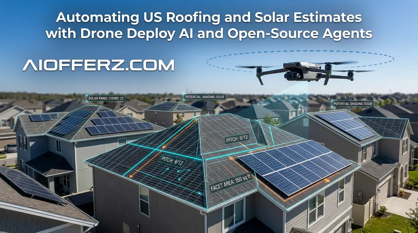
Instead we deployed a single commercial quadcopter equipped with a high-resolution visual sensor and a radiometric thermal payload.
Within exactly forty-five minutes the entire site was mapped. By the time our truck pulled back into the office garage.
Our cloud-connected open-source AI agents had already parsed the photogrammetry data, extracted precise CAD-ready dimensions, calculated the exact solar irradiance potential for every single roof facet and generated a flawless, line-itemed commercial proposal.
The integration of autonomous hardware and advanced artificial intelligence is no longer a futuristic concept for forward-thinking United States exterior contractors.
It is a vital operational standard for businesses that intend to survive escalating labor costs, compressed insurance adjustment windows and the rapid velocity of modern clean energy deployments.
Transitioning from traditional hand-written assessments to automated estimate generation involves combining enterprise visual data collection platforms with lightweight, customizable open-source developer frameworks.
The Current Bottlenecks in Traditional Property Estimation
For decades the American roofing and solar sectors have relied on manual field estimation methods that inherit massive structural liabilities.
These traditional approaches drain operational profits while exposing contracting companies to significant regulatory and financial dangers.
Want To Use Other AI To Write…
Safety Risks and Insurance Overhead
Climbing steep residential pitches or navigating commercial single-ply membranes exposes field personnel to immediate fall hazards.
The United States Occupational Safety and Health Administration (OSHA) consistently ranks falls from elevations as the leading cause of fatalities within the construction sector.
For an active roofing enterprise, this translates directly into astronomical workers’ compensation insurance premiums and constant exposure to catastrophic liability claims.
When estimators spend their hours physically traversing valley lines and ridge caps to map physical dimensions, they are dramatically inflating the company’s risk profile without adding structural value to the actual measurement data.
Human Error and Scope Creep
Hand-measured takeoffs are notoriously imperfect.
A field technician utilizing a physical tape measure or a basic laser tool on a complex commercial roof with multiple intersecting valleys, dormers and mechanical equipment curbs will almost certainly introduce calculation errors.
An underestimation of just five percent on a large-scale commercial thermoplastic polyolefin (TPO) installation can entirely erase the profit margin of a project due to material shortages and emergency hot-shot delivery fees.
Conversely, overestimating material requirements makes bids uncompetitive in tight regional markets, causing sales pipelines to stall out completely.
The Problem with Slow Proposal Turnaround Times
Modern property owners expect lightning-fast communication.
If a storm restoration contractor or a residential solar developer takes five to seven business days to deliver a comprehensive, professional estimate after an initial site visit, the consumer will typically sign a contract with a faster competitor.
Manual estimation processes create deep internal administrative backlogs.
Draftsmen must translate hand-sketched field notes into digital computer-aided design (CAD) software, while sales engineers manually cross-reference local electrical code books for solar setback requirements.
This structural delay kills sales conversion rates.
Wanna Use CustomGPT AI…
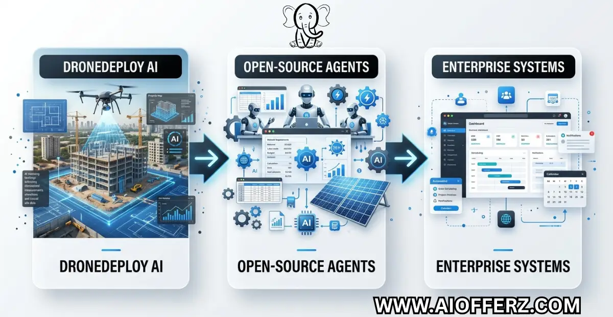
Deconstructing the Tech Stack: DroneDeploy AI Meet Open-Source Autonomy
Overcoming these operational limits requires a dual-layered technology architecture.
Enterprise grade aerial data capture platforms handle the physical environment mapping while custom open source programming frameworks orchestrate the downstream backend logic, financial modeling and CRM integration.
The workflow begins with the Aerial Capture Layer where the DroneDeploy Flight App and radiometric thermal sensors are used to collect aerial images, thermal data and site information.
This data is then sent to the AI Processing Engine where DroneDeploy Inspection AI and Progress AI perform cloud-based analysis, inspections and progress tracking.
After processing, the information moves to the Open-Source Agent Layer, where custom Python agents built with LangChain and CrewAI, along with local LLM parsing, automate various tasks and extract useful insights from the data.
The processed information is delivered to Enterprise Endpoints such as Xactimate Data, HubSpot CRM, Procore and Solar Design Engine, allowing businesses to generate estimates.
Also manage customer relationships, coordinate projects and create optimized solar designs within a unified workflow.
DroneDeploy as the Core Visual Infrastructure
DroneDeploy operates as the foundation of the automated inspection workflow. The software controls the flight path automation, camera triggering and raw visual data compilation.
Rather than forcing a human pilot to manually guide a drone over a structure, the system utilizes pre-mapped flight boundaries to execute perfect, overlapping autonomous grids.
The cloud platform processes thousands of raw aerial photographs into a high-density, georeferenced orthomosaic map, a highly accurate 3D point cloud and an interactive digital surface model.
DroneDeploy’s specialized native AI models analyze these assets in real time to automatically isolate distinct roof facets, calculate precise surface areas, detect slopes and identify structural anomalies or thermal variances indicating hidden moisture intrusion.
Using Many AI’s For Many Work, Solution Is Here…
The Role of Open-Source Agents
While DroneDeploy excels at generating the core geometric and visual datasets, a custom open-source agent framework is what transforms this raw spatial information into a comprehensive commercial estimate.
By leveraging open-source Python frameworks like LangChain, CrewAI or AutoGen, developers can assemble autonomous digital workers capable of executing complex business operations.
These local or cloud-hosted open-source software agents are programmed with specific tools and strict behavioral boundaries.
For example, an estimation agent can receive raw JSON measurement exports directly from the DroneDeploy API.
It then runs that data against localized building material databases, regional distributor price lists and current labor rate calculations to build an itemized bill of materials without requiring human administrative input.
Setting Up Autonomous Flight Operations for Roofing and Solar Data
Capturing highly accurate aerial data capable of driving automated pricing models requires systematic field execution.
The accuracy of your automated artificial intelligence estimate is directly dependent on the clarity and structural integrity of the initial visual flight telemetry.
Pre-Flight Planning and LAANC Authorization
Before any drone leaves the ground on an American job site, the pilot in command must satisfy all federal regulatory criteria.
Under the Federal Aviation Administration (FAA) Part 107 regulations, commercial drone flights must occur within approved airspaces and follow strict operational safety parameters.
Modern flight mapping tools integrate directly with Low Altitude Authorization and Notification Capability (LAANC) provider networks.
This allows pilots to request and receive near-instantaneous digital flight clearance when operating inside controlled airspace zones near major domestic airports.
Pre-flight planning software also maps out terrain boundaries, cross-references local wind gusts and establishes precise altitude thresholds to guarantee the drone maintains a consistent distance from the roof structures throughout the visual data collection pass.
“Live Chat Jobs – You have to try this one”
Executing Visual and Thermal Captures
For comprehensive roofing and solar assessments, an autonomous flight plan should incorporate two distinct sensor captures:
-
High-Resolution Visual Photogrammetry: The drone flies a nadir (top-down) grid pattern combined with oblique (angled) perimeter sweeps. The camera captures images with a minimum seventy-five percent frontal and side overlap.
This massive visual redundancy provides the cloud photogrammetry engine with the data points required to construct a millimeter-accurate 3D mesh model showing every fascia board, gutter line, flashing detail and shingle defect.
-
Radiometric Thermal Mapping: Essential for commercial low-slope roofing systems and active solar farm performance audits.
Flying an uncooled radiometric infrared sensor after sunset allows contractors to capture the thermal signature of the roof deck.
Because water has a higher thermal mass than dry insulation material, sections of the roof containing trapped moisture retain heat longer and show up as distinct glowing anomalies on the processed thermal map.
Processing the Spatial Data with DroneDeploy AI
Once the flight mission concludes, the raw image directory is synced directly to the cloud rendering pipeline. This is where artificial intelligence processes the raw imagery to extract structured architectural insights.
Try it to make the body more active and healthy.
Geometric Extraction and 3D Modeling
The photogrammetry engine instantly calculates the precise spatial location of every pixel across the collection of aerial images.
This process creates an interactive 3D digital duplicate of the property. DroneDeploy’s deep-learning visual segmentation models immediately identify the structural layout of the roofing system.
The AI labels every single ridge, hip, valley, rake and eave line across the structure. It automatically determines the exact pitch angle of every separate roof facet by analyzing the relative Z-axis values within the georeferenced point cloud.
This completely eliminates the need for human estimators to manually draw line paths or interpret complex multi-angled blueprints.
Automated Defect and Irradiance Mapping
For roofing contractors, DroneDeploy’s automated inspection tools scan the high-resolution texture maps to identify structural anomalies.
The system flags missing architectural shingles, exposed fastener heads, wind-uplift damage, and localized cracking on modified bitumen surfaces.
For solar developers, the system evaluates the digital surface model alongside historical weather patterns to map solar irradiance potential.
The software calculates exactly how much sunlight hits every square foot of the roof surface over a twelve-month cycle.
It automatically identifies performance-killing shade hazards caused by overhanging tree limbs, neighboring structures, commercial HVAC units or plumbing vent stacks, ensuring solar panels are only scheduled for placement on optimal high-yield facets.
You can use it naturally as an effective Dental Care tool.
Orchestrating Open-Source Agents for Automated Estimating
Once DroneDeploy completes the architectural processing, the custom open-source agent layer takes over to run the financial and logistical computations.
Architectural Layout of the Custom Developer Pipeline
The open-source agent infrastructure functions as a highly specialized, multi-tiered digital workforce. A primary coordination agent monitors the DroneDeploy API webhooks.
The moment a roof flight finish-processing notification triggers, this coordinator agent fetches the complete spatial data payload which contains a clean JSON breakdown of all structural measurements, area calculations and defect listings.
The coordinator then splits the workflow and assigns micro-tasks to dedicated subordinate agents:
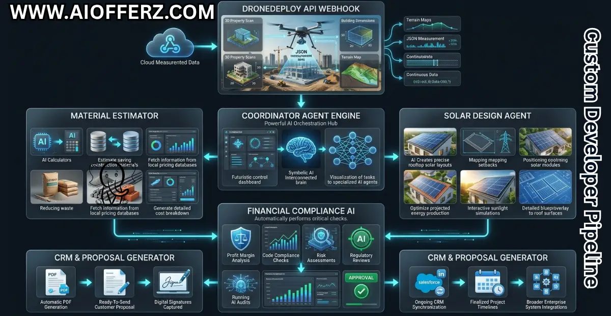
Scripting an Automated Python Material Estimator Agent
Below is a clean, practical blueprint for an open-source Python agent using a structured agent pattern.
This script ingests the geometric JSON metadata from the aerial mapping system, applies regional waste-factor logic, fetches current distributor material pricing, and formats a clean estimating output.
You can go for this to get natural Glowing Skin
Bridging the Gap: Automated Solar Array Placement Layouts
For clean energy developers, the open-source agent integration goes significantly deeper than basic material counts.
Once the system establishes an accurate structural 3D layout, a specialized solar design agent determines the optimal solar panel layouts across the available roofing surfaces.
Enforcing Local Setback Codes
National fire protection regulations and regional municipal building frameworks demand strict boundaries along roof surfaces to ensure emergency first-responder access paths.
Solar systems cannot simply cover every square inch of a residential or commercial roof deck. The open-source design agent reads local municipality guidelines based on the property’s ZIP code coordinates.
It automatically applies required eighteen-inch or thirty-six-inch safety setbacks along all primary ridge lines, hip transitions and valley intersections, drawing clear boundary boxes within the spatial coordinate map where solar panel mounting rails can legally fit.
Powerful brain supplement that protects you from mental exhaustion.
Maximizing Electrical Kilowatt-Hour Production Trajectories
The design agent runs a mathematical packing optimization loop inside the safe boundary zones. It aligns virtual solar module blocks against the exact pitch and azimuth data provided by DroneDeploy.
The agent tests both portrait and landscape physical panel orientations to see which layout accommodates the highest count of modules.
Because it factors in the precise annual shade casting data compiled during the cloud analysis phase, the agent automatically drops low-performing panels that fall below an acceptable annual kilowatt-hour generation threshold.
The result is an optimized solar array layout engineered for peak energy output, completely prepared to be passed straight into engineering documents or client sales presentations.
Connecting the AI Pipeline to CRM and Construction ERP Software
An autonomous pipeline provides maximum business value when it communicates with your core operations stack.
Open-source agents serve as the intelligent data bridge that completely removes manual data entry between your field mapping software and your core office systems.
Syncing Field Intelligence Directly to Sales Pipelines
The moment an aerial inspection mission finishes processing, the automated agent parses the structural metrics and updates the specific customer record inside your CRM system, such as HubSpot or Salesforce.
The agent attaches the high-definition orthomosaic mapping links, drops the itemized construction cost figures straight into custom property fields and automatically moves the deal stage forward from “Site Inspection Completed” to “Proposal Prepared.”
This keeps the entire sales team perfectly informed in real time without forcing field technicians to spend their evenings typing notes or uploading large file attachments manually.
Generating Invoices and Purchase Orders
The open-source agent pipeline pushes the finalized material bill directly into construction resource planning tools like Procore, QuickBooks or Buildertrend.
The agent drafts an exact, unpriced purchase order detailing the exact quantities of architectural shingles, rolls of synthetic underlayment, cartons of coil nails and bundles of ventilation accessories required for the project.
This draft is routed straight to the purchasing manager’s screen for single-click confirmation, preventing the material over-ordering issues that consistently chip away at standard contracting margins.
If you want to stay healthy and fit, also loss your weight naturally then use it.
The Financial Impact: Real-World ROI Analysis
Adopting an integrated workflow driven by autonomous drones and open-source software agents fundamentally reworks the financial dynamics of exterior contracting enterprises.
| Operational Milestone | Legacy Manual Procedures | Autonomous AI & Agent Pipeline |
| Site Data Collection Duration | 3.5 Hours (Two Field Estimators) | 45 Minutes (Single Drone Operator) |
| Data Calculation Accuracy | +/- 8% Standard Dimensional Variance | +/- 1% High-Density Point Cloud Precision |
| Turnaround Time for Estimates | 72 to 120 Business Hours | 15 Minutes Post-Flight Processing Sync |
| Field Labor Safety Incidents | Variable Height Fall Exposure Risks | 0% Risk (Ground-Based Operations) |
Evaluating these figures across a standard operating year reveals massive cost reductions.
By cutting on-site field assessment times by over seventy-five percent, a standard roofing or solar enterprise can comfortably triple its weekly property assessment volume without adding operational headcount.
The absolute removal of material ordering mistakes combined with the rapid turnaround of professional, hyper-accurate sales proposals gives early adopters an undeniable competitive advantage in domestic contracting markets.
FAQs
1. What specific FAA regulations must commercial roofing businesses satisfy to operate mapping drones legally in the United States?
To execute commercial drone operations for roofing or solar assessments anywhere within the United States, your operators must strictly comply with the FAA’s Part 107 regulations.
This framework mandates that the person operating the drone must pass an initial aeronautical knowledge exam at an approved testing site to obtain a valid Remote Pilot Certificate.
Operationally, the drone must remain within the pilot’s direct visual line of sight at all times, stay below an altitude of four hundred feet above ground level and avoid flying directly over unprotected individuals unless using a drone equipped with compliant, certified safety shrouds or parachutes.
2. How well do DroneDeploy’s visual artificial intelligence models perform when assessing properties covered in dense tree canopies?
DroneDeploy’s advanced photogrammetry processing relies heavily on clear, unobstructed visual lines of sight to build accurate structural models.
When dense foliage or overhanging tree limbs physically hide sections of a roof line, the software’s AI tools cannot directly calculate the geometric points beneath that canopy.
In these specific real-world situations, the platform flags the obstructed areas for review. Field operators can supplement the flight data by capturing manual ground-level photos with a tablet or mobile phone.
Allowing the underlying open-source processing agents to combine those surface viewpoints and patch the obscured sections of the layout.
3. Can open-source agents integrate with standard estimation platforms like Xactimate or Symbility for insurance work?
Yes, open-source Python agents excel at structuring and translating spatial data into file formats compatible with insurance platforms.
While enterprise insurance applications like Xactimate operate within secure environments, they readily import standardized data files such as ESX components or formatted XML files.
Your custom open-source agents can easily take the raw geometric dimensions extracted from DroneDeploy, arrange those values into the exact structured layout required by insurance carriers and output a clean import file that populates your insurance estimating software without requiring manual data entry.
4. What are the baseline hardware requirements for a drone program focused on automated property mapping?
To achieve the spatial precision necessary for automated estimating, you do not need ultra-expensive military hardware but you do need reliable enterprise-grade equipment.
The drone platform must feature a high-resolution visual sensor (at least twenty megapixels) with a mechanical shutter.
Mechanical shutters are essential because they eliminate the rolling-shutter distortion that occurs when a drone captures images while moving quickly, ensuring your 3D models remain geometrically accurate.
If you intend to map commercial flat roofs for subsurface leaks, the drone must also carry a dual-payload configuration that includes an uncooled radiometric thermal sensor.
5. How do open-source AI agents handle changing regional building regulations and local material cost updates?
Because open-source agents are written using standard Python frameworks, they can easily connect to external live databases. Instead of hardcoding static prices or local rules into the script, developers program the agents to query external web APIs.
When an agent receives an estimation task, it uses the property’s ZIP code to pull up the active municipal building codes and real-time distributor price books for that exact market.
This ensures that every generated quote automatically accounts for localized requirements, such as ice-dam protection membrane mandates in northern states or wind-uplift fasteners in coastal areas.
6. What steps should a contractor take if an automated AI estimate contains an obvious calculation error?
The automated agent pipeline should never be allowed to send a contract straight to a property owner without human confirmation.
The architecture must always include a human-in-the-loop validation step. The open-source agents build the estimate and flag any potential anomalies such as unusual pitch changes or extreme waste factors for manual review.
Your human estimator opens the draft project inside your corporate CRM dashboard, reviews the automated line items against the aerial map, makes any necessary adjustments and signs off on the final proposal before it goes out to the client.
7. How does a thermal drone locate moisture damage on a low-slope commercial roof membrane?
Thermal moisture detection relies on solar capacitance which is the natural difference in heat retention between wet and dry materials.
Throughout a sunny day, water trapped beneath a roof membrane absorbs a massive amount of thermal energy.
When the sun sets and the air temperature drops, the dry sections of the roof shed their heat quickly while the wet insulation holds onto its energy much longer.
Flying a radiometric thermal drone over the roof during this evening cooling window reveals the wet sections as distinct, brightly glowing areas on the infrared map, allowing crews to pinpoint exactly where repairs are needed.
8. Are open-source agents secure enough to safely handle sensitive commercial client data?
Open-source agents are highly secure because you maintain complete ownership and control over where they are deployed.
Unlike closed, proprietary software platforms that force you to upload your sensitive customer files onto their remote servers, open-source agent frameworks run entirely within your own secure cloud environment (such as AWS or Google Cloud) or on your local office workstations.
This ensures that your client records, proprietary material pricing strategies and private corporate data never leave your direct control or expose you to third-party security vulnerabilities.
9. What is the average timeframe required to deploy a custom drone and agent estimation pipeline?
Building and launching a fully integrated automated estimation system typically takes between four and eight weeks of development time.
The first phase focuses on setting up your autonomous flight operations and configuring your DroneDeploy API connections.
The second phase involves writing the custom open-source Python scripts that match your company’s unique estimating logic, labor rates, and waste factors.
Once the backend code is tested, the system is linked to your existing CRM and ERP applications, allowing you to run small-scale field tests before rolling out the workflow across your entire enterprise.
10. How do automated drone estimates perform on highly complex commercial roofs with extensive mechanical systems?
Automated drone mapping systems perform exceptionally well on complex commercial roofs because their sensors capture finer details than any human estimator could measure by hand.
While a field technician might struggle to manually measure around dozens of commercial HVAC curves, electrical conduits, and complex elevator penthouses, a drone mapping run captures all of these elements simultaneously in a high-density 3D point cloud.
DroneDeploy’s inspection artificial intelligence automatically identifies these mechanical obstructions, isolates them from the usable roof surface area.
And provides your open-source agents with clean geometric totals that guarantee your solar layouts or material counts are perfectly accurate.
Ready to Begin?
➜ Click Here to explore top rated affiliate programs on ClickBank!
➜ Reach Our Free Offers: “Come Here To Earn Money By Your Mobile Easily in 2025.”
Want To Read More Then Click Here…
If You Are Interested In Health And Fitness Articles Then Click Here.
If You Are Interested In Indian Share Market Articles Then Click Here.
Thanks To Visit Our Website-We Will Wait For You Come Again Soon…
Want To Read More About AI Then Click Here…